Urban Fringe Map, Floodway Development Restrictions, and Campus Community Commission
 |
Bronwyn Beatty-Hansen's Council Preview |
The Ames City Council begins at 6:00 PM with a meeting of Ames Area Metropolitan Planning Organization Transportation Policy Committee. The Regular City Council Meeting will immediately follow.
The agenda includes:
-
37. Resolution approving/motion denying Ames Urban Fringe Plan Map Amendment for East Industrial Area.
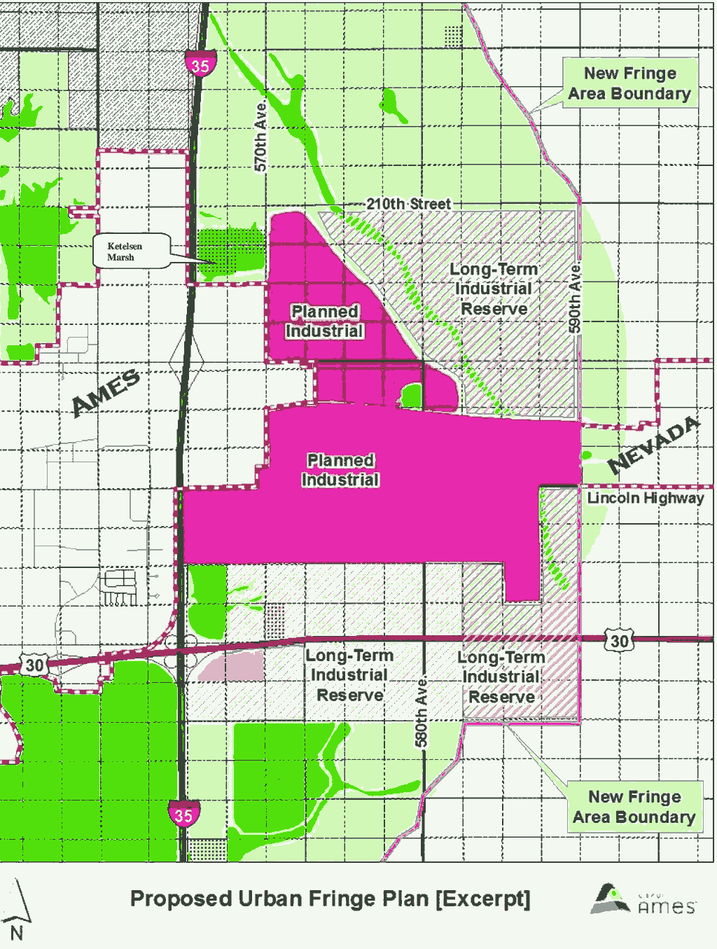
Council has approved installing sewer and water east to 590th St. to create the East Industrial Area. To do so requires annexation, but first a change in the Urban Fringe Map (Part of the Land Use Policy Plan). In addition to the area immediately affected (marked as "planned industrial" on this map), staff is proposing land to the north and south be designated as "industrial reserve". The "industrial reserve" areas would be for long-term future uses, and may not be utilized for 30+ years. They would need to be re-classified as "planned industrial" before the city could annex and use those areas. There are several significant issues with this East Industrial area. Installing the infrastructure is a big investment, but as a city we want to make sure we fill the area with the right type of businesses. Once we invest in the area, pressure will build to fill the space, but we should only do so with industry which will be good for Ames in the long run.
-
38. Walmart at Grand Avenue and 30th Street (Joint Use Parking Agreement with North Grand Mall).
Walmart is proposing a plat of survey to combine two lots, totaling 14+ acres. (One is the current Walmart lot, the second is the old Cub Foods/Dahls lot.) According to city code, Walmart is required to complete a sidewalk along Wheeler Street before the plat of survey. They are requesting a deferral on sidewalk improvements until site redevelopment and will give a security deposit in the amount of the needed improvements. Walmart will also reach an agreement with North Grand Mall regarding parking while their site is under construction. -
39. Update on Flood Plain and Environmentally Sensitive Overlay and Map Amendments.
In November 2015, Council directed staff to prepare a map, designating floodways with an “Environmentally Sensitive Overlay” (O-E) and require major site development plan oversight. The Planning and Zoning Commission heard input on this and recommended (5-0) against the requirement for an additional layer of major site development plan approval. P&Z did recommend (3-2-1) the change to O-E, but without language about the site plan, this yields inconsistent policies. Council will have to decide whether to move forward with their original recommendation to staff, address only the parking issue related to floodway development, or abandon changes. -
40. Lincoln Way Pedestrian Crossing Data Collection and Analysis (University Boulevard to Sheldon Avenue).
In light of increased enrollment, traffic, and the tragic pedestrian death near campus recently, the City and ISU and embarking on a joint study of traffic safety along Lincoln Way. This will be a separate study from the "Lincoln Way Corridor Study", allowing those consultants to focus more on topics like planning and land use. The safety study will involve recording and counting traffic (pedestrians, bicycles, cars, & other vehicles) at intersections from University Blvd to Sheldon Ave.
-
41. Staff report on Campus Community Commission.
There has been renewed interest in forming a group or commission of citizens and students to weigh in on issues in the campus and Campustown areas. The now-defunct Student Affairs Commission was formed in 2008 to meet this need, but had stringent membership requirements. Several methods to proceed with a new avenue for gathering citizen and student input have been proposed including a 28E (intergovernmental) agreement between ISU and Ames to create topic-specific task forces, or the creation of a Campus Community Commission. -
44. Hearing on Urban Revitalization Plan for 3505 and 3515 Lincoln Way.
In 2015, Council directed staff to create an Urban Revitalization Plan for these two properties (currently under construction) at 3505 and 3515 Lincoln Way. The plan requires conforming to the Major Site Development Plan (approved by Council in September 2015) and requires participation in the Crime Free Housing Program in order to achieve tax abatement.
Thanks for reading,
Bronwyn Beatty-Hansen
City Council At-Large
| Others can subscribe at |  |
| Follow Council News on |  |
| View council on line live at |  |
Any corrections or additions to this email will be posted at the Council Preview Blog.